Randonnée Marche Gorges du Tarn Causses - Le tomple - Photo
 Catherine_Castel
Catherine_Castel

Utilisateur

© OpenStreetMap contributors
Longueur
Longueur
9,1 km
Altitude max
Altitude max
1006 m
Dénivelé positif
Dénivelé positif
395 m
Km-Effort
Km-Effort  
14,4 km
Altitude min
Altitude min
611 m
Dénivelé négatif
Dénivelé négatif
397 m
Boucle
Boucle
Oui
Date de création :
2021-04-12 11:56:09.795
Dernière modification :
2021-04-12 14:20:40.584

(0 Avis)

Marche
Marche
2h23
Difficulté : Difficile

Scannez ce code QR pour ouvrir la randonnée dans l'application SityTrail

Application GPS de randonnée GRATUITE

Logo SityTrail SityTrail

IGN / Instituts géographiques

Télécharger SityTrail sur l'App Store Télécharger SityTrail sur Google Play

Logo SityTrail SityTrail World

Le monde est à vous

Télécharger SityTrail sur l'App Store Télécharger SityTrail sur Google Play Télécharger SityTrail sur Huawei AppGallery

À propos

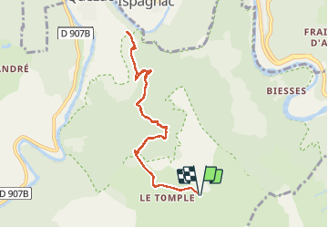
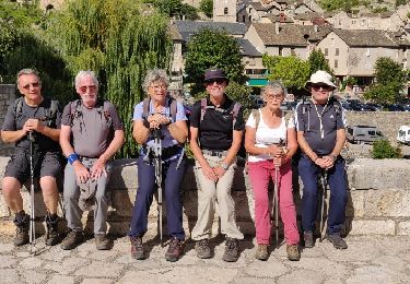
Randonnée Marche de 9,1 km à découvrir à Occitanie, Lozère, Gorges du Tarn Causses. Cette randonnée est proposée par Catherine_Castel.

Profil altimétrique

Localisation

Pays :
France
Région :
Occitanie
Département/Province :
Lozère
Commune :
Gorges du Tarn Causses
Localité :
Quézac
Départ:(UTM)
543485 ; 4910231 (31T) N.

Randonnées à proximité

Randonnée Marche Florac Trois Rivières - Le Sentier des Couronnes - Florac - Photo
Marche
tracegps

Marche

Difficile
(4)
Florac Trois Rivières, Occitanie, Lozère, France
15,3 km | 24 km-effort
5h 0min
Oui
Randonnée Marche Ispagnac - Ispagnac et Quezac - Photo
Marche
PascaleJ

Marche

Facile
(2)
Ispagnac, Occitanie, Lozère, France
8,8 km | 12,5 km-effort
2h 22min
Oui
Randonnée Marche Florac Trois Rivières - Panoramique des couronnes - Photo
Marche
GUIDE
nadinebondoux

Marche

Difficile
Florac Trois Rivières, Occitanie, Lozère, France
14,9 km | 23 km-effort
5h 43min
Oui
Randonnée V.T.T. Vebron - Boucle Causse Méjean - Photo
V.T.T.
phcol

V.T.T.

Facile
(2)
Vebron, Occitanie, Lozère, France
30 km | 37 km-effort
2h 27min
Oui
Randonnée Marche Florac Trois Rivières - Etape 8 Florac/Cassagnas - Photo
Marche
Nathalie. Mercier

Marche

Moyen
Florac Trois Rivières, Occitanie, Lozère, France
20 km | 26 km-effort
5h 20min
Non
Randonnée Marche Florac Trois Rivières - Au long du Tarn: de Florac à St Enimie par le Causse de Sauveterre - Photo
Marche
canardDenis

Marche

Très difficile
Florac Trois Rivières, Occitanie, Lozère, France
27 km | 41 km-effort
9h 26min
Non
Randonnée Marche Gorges du Tarn Causses - La Condamine, le Single  - Photo
Marche
Gegetop

Marche

Facile
Gorges du Tarn Causses, Occitanie, Lozère, France
11,3 km | 14,8 km-effort
3h 15min
Oui
Randonnée Marche Florac Trois Rivières - Monteils  - Photo
Marche
Gegetop

Marche

Moyen
Florac Trois Rivières, Occitanie, Lozère, France
12,2 km | 17,1 km-effort
3h 40min
Oui
Randonnée Marche Florac Trois Rivières - Tour du Causse Méjean - Etape 8 - Photo
Marche
nolsim

Marche

Moyen
Florac Trois Rivières, Occitanie, Lozère, France
29 km | 37 km-effort
7h 57min
Non


Fermer
Mes abonnements